
Sinker Butte


Sinker Butte is the highest plateau near the Swan Falls Dam in Murphy, Idaho. It lends itself to pristine views of the surrounding area including the Snake River, Owyhee Mountains, and constant buffeting from the unimpeded wind...but the views sure are worth it.
WORD of WARNING: There is no cell phone signal reception down in the valley along the Snake River. Plan accordingly.
Access to the trailhead begins at Swan Falls Dam. You have to cross the river using the dam's walkways. This is typically open to the public when the adjacent park is open to the public. Once you cross the dam to the other side of the Snake River you have several trails that can lead to any number of areas. Be sure and take a map or use an app that has the trail on it so you can follow along, at least through the initial part of the hike.
While crossing the dam you might stop and see if anyone on the river below the dam has hooked into a sturgeon. These massive fish are incredible and protected in Idaho. You can catch them in the Snake River, but you must release them without removing them from the water. Check out this link to learn more: Idaho Sturgeon.
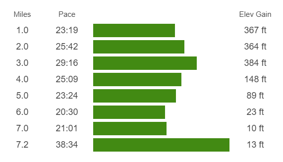
The hike's difficulty is moderate to hard depending on your level of conditioning. There are three areas where the elevation gain can have you sucking some wind. Take it slow and you should be fine. Remember "baby steps" when hiking uphill.
Once you cross the dam and reach the other side of the river the hike really begins. You start by hiking along the river above the dam. Take in the views here. There is usually a variety of waterfowl here, playfully swimming in the calm water. Keep an eye out for the thorny blackberry stems that sometimes reach out into the trail. They will get ya if you're not careful. The trail in this area can be pretty dusty if it has been dry for more than a few days. Take your time and you'll keep the dust down for people behind you or those you pass on the trail.
After a short hike along the river, you'll follow the trail as it turns right and begins to head up toward the canyon walls. This is the first bit of elevation gain. Take your time and don't burn too much energy here, you'll need it later on. Baby steps up the small elevation gain.
When the trail levels off again take a moment to take in the view of the river and canyon from this perspective. In spring the water may be more brown, while in the fall and winter, it can be a beautiful blue or slightly green color. The view is lovely any time of year. Take it in a while maybe getting a little water or a few good deep breaths.
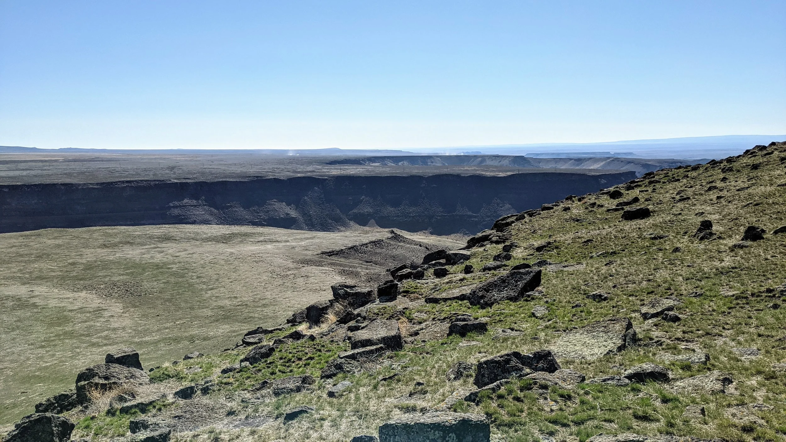
The second elevation gain is a bit more as you actually hike up the major section of the canyon wall. Along the way watch for the stone heart. It has been there for some time and is a cute little spot to stop and rest if you need it. Take in the views again and enjoy the day. This hike will be memorable because of the views, so don't hustle through it and miss everything that makes this hike amazing.
After escaping the canyon you'll still have to gain elevation for the remainder of this hike but the next section will be a pretty gradual gain in comparison. You connect with a wider 4x4 road or BLM road. Still dirt, still dusty in dry times, but only a gradual incline.
This will go on for a bit, but keep an eye out ahead of you and to the left. You will see a barbed wire fence that comes to a corner. When you see it you will want to leave the trail and head for that green gated fence corner. You'll need to either go over or under the fence. If you go under watch your hands, the ground is usually covered in prickly dry weeds that blend into the dirt. Put your hands on the ground and you'll end up with a small handful as a painful memento.
From here you are at the steepest part of the hike. Look for the small seam that leads to the top of Sinker Butte and start hiking. Baby steps your way to the top. It's not over when you think it is though.
Once you get past the steep climb you keep going along the steady uphill. Keep an eye out for the American Flag that will hopefully be flapping in the constant breeze, or gale-force winds that never cease at this point of the hike. The flag is the highest point of Sinker Butte and gives an incredible view of the entire area. There is also a logbook located near the flag. Sign it if you like and let others know you were there. This is a great place to take lots of pictures, grab a bite to eat, drink some water, and just relax and enjoy the view.
Comfort Note: If the weather is a bit chilly on the day of your hike, pack a jacket. You may not wear it most of the hike but you will thank me later when you reach the top of Sinker Butte. The chill in the air, combined with the sweat you worked up during your hike, turns you into an ice box when the wind constantly buffets you with little for you to shelter behind.
From the top, you can head back down the way you came or you can explore a little. We hiked to the canyon rim and looked out over the Snake River. There are several areas here that are very picturesque. Take your time and enjoy the views. They are breathtaking.
Whatever path you take, find your way back to the green gated fence corner, then make your way from there back the way you came until you get back to the park at Swan Falls Dam. Take a few minutes to look back up the canyon to where you were and find pride and pleasure in what you accomplished and the beauty you were able to see.