
China Ditch Trail


Located just 14 miles (22.53 km) West of Melba, ID, and 3.5 miles (5.63 km) West of Wilson, ID, China Ditch Trail is a 7.4 mile (11.91 km) trail, give or take a half mile depending on the paths you take. The goal of this particular trail is to see the Chinese ditches that were created by Chinese laborers in the 1850s. The ditches were used to capture water before it reached Reynold’s Creek and divert it to their crops and the mining camps in the area. You can tack a few other things onto this hike as well. For example: hiking through part of Mini Moab and finishing the hike on top of the rocky peak above the parking lot for an incredible view of the Owyhee Mountains and surrounding area. If you follow the trail above, you will do all three. If you go on a hot day, you can even take a dip in Reynold’s Creek to cool off. Getting wet was out of the question since the temperature would not climb above 50, and rain was intermittent during our hike.
Challenges:
There are a number of trails in this area, and not all lead you where you will want to end up. A 7-mile hike could become much more if you get on the wrong trail. I highly recommend a navigation tool like AllTrails, just in case.
The trails are narrow in parts but are well-worn, without many tripping hazards to worry about for most of the hike. There are some more rough areas in the canyon along Reynold’s Creek.
There is very little elevation change throughout most of the hike. Accessing and leaving the canyon along Reynold’s Creek was the most difficult part; climbing out was the most difficult part. If you have difficulty in this kind of terrain, walking sticks would be a good option.
If you climb to the top of the rocky peak above the parking lot, be prepared for the steep climb. You can go off-trail, but there is a trail that will get you there more easily if you trust it.
If you go in the spring, summer, or early fall, bring water, sunscreen, and a hat. There is virtually no shade, and it will be hot, usually.
Equipment:
Water
Snack
Sunscreen (recommended)
Bug Repellent (recommended)
Hat (recommended)
Good, broken-in hiking boots or shoes
Weather-appropriate clothing
The Approach
Heading West on Melba Rd, you’ll take a left onto ID-45 South. Follow ID-45 South past Dan’s Ferry Service and the gas station, across the bridge, and then turn right at the first cross street onto ID-78 West. Follow ID-78 West until you reach the small community of Wilson. Turn left onto Wilson Creek Rd. Just past the Wilson Creek Cattle Feeders, you’ll see the overflow parking lot for Wilson Creek Trails. Keep going to the primary parking lot, just a little further ahead. If the primary parking lot is full, you can always turn around and park in the overflow. Both parking areas have vault toilet access.
Sharing the Trail
You’ll probably notice vehicles with mountain bikes and vehicles towing horse trailers. This area is open to both, so be prepared to share the trail and watch for the mountain bikers coming out of blind corners and over ridges on steep slopes. If you have dogs, they must be kept on a leash at all times. If your dog spooks a horse and causes damage to the horse or the rider, you could be held liable. The same goes for dogs getting in the way or causing issues for bike riders or other hikers. There are already issues with the cattle ranchers and those who use these trails. Don’t make it worse by having your dog off-leash and causing issues with the cattle.
The Trail
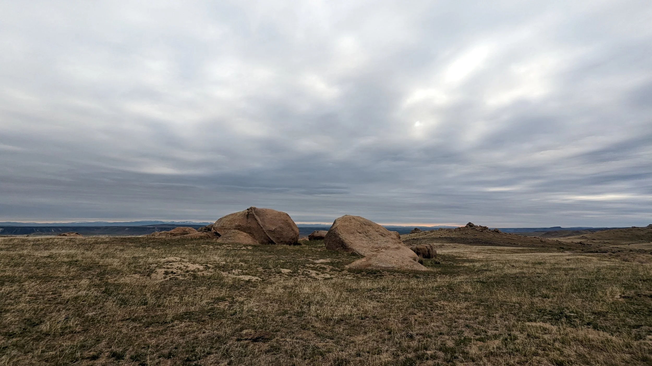
The first thing you’ll notice is the rocky peak overlooking the parking lot and the trail that leads straight up to the top. The second thing you’ll notice, after looking around for a bit, is that several trails lead away from the parking lot. This is the beginning of the spider’s web of trails in this area. If you do not have people with you who know this trail well, you really should have an app or something to help you keep on the right trails during this hike. Once you get onto the right trail, you be heading almost due South. The trail from here to the canyon will be mostly flat, with some slight elevation changes along the way. Enjoy the views of the wide open spaces, but mind your footing since some rocks are in the trail. There is a great little selfie spot at about the 1.5 mile (2.41 km) mark. A large boulder along the trail has an opening in the side and top where you can climb in and stick your head out of the hole on the top. Selfies may actually be difficult, but if you are hiking with others, then take turns taking pictures for one another.
At about the 2-mile mark, you’ll come to a crossroads. To visit a portion of Mini Moab, you’ll take the Southeastern trail. The Mini Moab route takes you through some incredible rock formations where rock displaced by ancient volcanic activity has been exposed after millions of years of erosion, removing the sand and soil around them. The contrast in the landscape is stark and is a great opportunity to take some interesting pictures and explore the terrain. Another hike in this area takes you through all the sections of Mini Moab, called the Wilson Creek Mini Moab Loop. It is over 10 miles (16.09 km) in length and has a greater elevation shift over its length.
Mini Moab Rock Formation
After exiting this section of Mini Moab, you have a half-mile hike to the overlook of Reynold’s Creek and the first look at the ditches built by the Chinese immigrants over 170 years ago. This is a great point to pause and take in the view. Take some pictures, drink some water, and maybe have a snack. The ditches can be seen on either side of the creek, but the better view is of the one on the east side of the creek. They are built from tens of thousands of stones, running for approximately 1.5 miles (2.41 km) on either side of the creek. They are 3 feet (0.91 m) wide and 2 feet (0.61 m) deep. In the 1970s, the ditches were deteriorating quickly. The Owyhee County Parks & Recreation Department created the trail system, capturing 2/3 of a mile of the western ditch in order to be able to maintain and preserve it. It also allows visitors to see and contemplate what it might have been like to suffer through such a difficult task during such a difficult time.
I can’t imagine how long, and how many people, it took to construct these ditches in this desert landscape. The weight of the undertaking must have been enormous, and dangerous. This is not a hospitable region to try to live and work in, especially in a day with absolutely no modern conveniences. There is no wagon access, so the stones would have been carried in backpacks, bags, and possibly small carts. Hour after hour, day after day, fighting through the near constant wind, the rain, the cold, the heat. To think about and try to understand the struggle it must have been is impossible and very humbling. The conditions of their labor were known to have been equally unkind and brutal as well. It is a stark reminder of the world we have come from and the better one we are striving to build.
The hike along the western ditch into the canyon provides yet another diverse shift in landscape. You slowly work your way down toward the creek and are blessed with cool canyon breezes, rushing water, and glorious shade among the rocky cliffs on either side. This section is also considered to be part of Mini Moab, and is another great opportunity to stop and take some pictures and just enjoy the area and views. The canyon walls offer a unique view into the tumultuous world that existed before humanity ever made an appearance. The Rhyolite walls of the canyon speak of this upheaval in their layers, angles, and striations. I can only be grateful to not have been present when all of this was happening. What a chaotic world it must have been.
The hike through the canyon is 1.2 miles (1.93 km) and is mostly downhill or flat. At the end of the section you will come to a clearing in the canton where the trail will lead northwest, up and out of the canyon. Also, it’s a great place to hang out and take some pictures, drink some water, and eat a snack if you haven’t already. Ahead, is the most difficult section of the hike. It is a short but quite vertical climb out of the canyon, followed by a less steep climb out of the valley. You’ll want to watch for mountain bikes in this section, as they often come down this trail into the canyon and visibility is limited. Also, take your time and pause as needed. There are some great photo opportunities as you clamber out of the canyon if you pause to look for them. Look southwest, towards the head waters of Reynold’s Creek. With the right light, it is gorgeous.
At 4.7 miles (7.56 km) in, you will have reached the top of the hill and will have exiting the valley. All that is left is 2.5 miles (4.02 km) spanning over a single rolling hill. Unless, you decide to summit the rocky peak above the parking lot on your way out, of course. Along this section you’ll see some different rock formation and probably some cattle. You’ll meet up with the trail you came in on along the way, but if you follow our path, you won’t be on it for long. We took the eastern trail out, putting us along the opposite side of the rock formations we saw on the way in. It’s not a dramatic shift, but it makes the trek out different from the trek in, which is our personal preference.
Nearing the end, we reached the fork in the trail where we had to decide. Do we continue on the easy trail back to the parking lot, or do we take the fork and summit the rocky peak? Always seeking the adventure, we chose the summit. This is where things get…interesting. When you are actively tracking a trail in AllTrails, it does allow for some flexibility. However, if you divert too much from the designated path in the system, then you get notifications that you are “off trail.” Of course, we breached the system and were immediately warned. Ignoring the warning, we followed the trail for a time, but became nervous that it was simply a trail that crossed over the ridge to the trail we hiked in on. Without our map working, we couldn’t confirm or deny that this trail would intersect with a trail heading North to the rocky peak, so we improvised. We literally went “off trail” and made our own way towards the rocky peak. After crossing about 100 yards (91.44 m) of difficult terrain, we stumbled upon a trail, the trail that intersects the one we were on and leads right to the rocky peak. So our choice of seeking adventure ended up leading to a little more adventure than anticipated. Such is life.
The trail to the peak is all elevation gain, but it was much less difficult than our off trail hiking. We soon reached the top, and we were gifted an incredible view of the entire area. It was well worth the effort required to reach this point. We took time to watch others from our group who took the flat trail back to the parking lot, ant-like in appearance, as they reached the end of the trail and bustled around their vehicles. We took in the scenic view and breathed deeply from the cool, fresh air that was beginning to warm as the sun emerged from behind overcast skies. It was the moment of culmination of an adventure that began in mystery and trepidation. We let gratitude fill us for having been able to experience this hike, for the healing power of the natural world, and for the peace of experience atop that peak. With invigorated souls, we scrambled down the northern trail towards the parking lot. We found amusement and intrigue seeing bike tire tracks in the steep trail where footing was at a premium. Approaching our car, we joined back with the group we began this journey with. We laughed and joked before bidding our goodbyes. Always ending with the salutation, “See you on the next one.”