
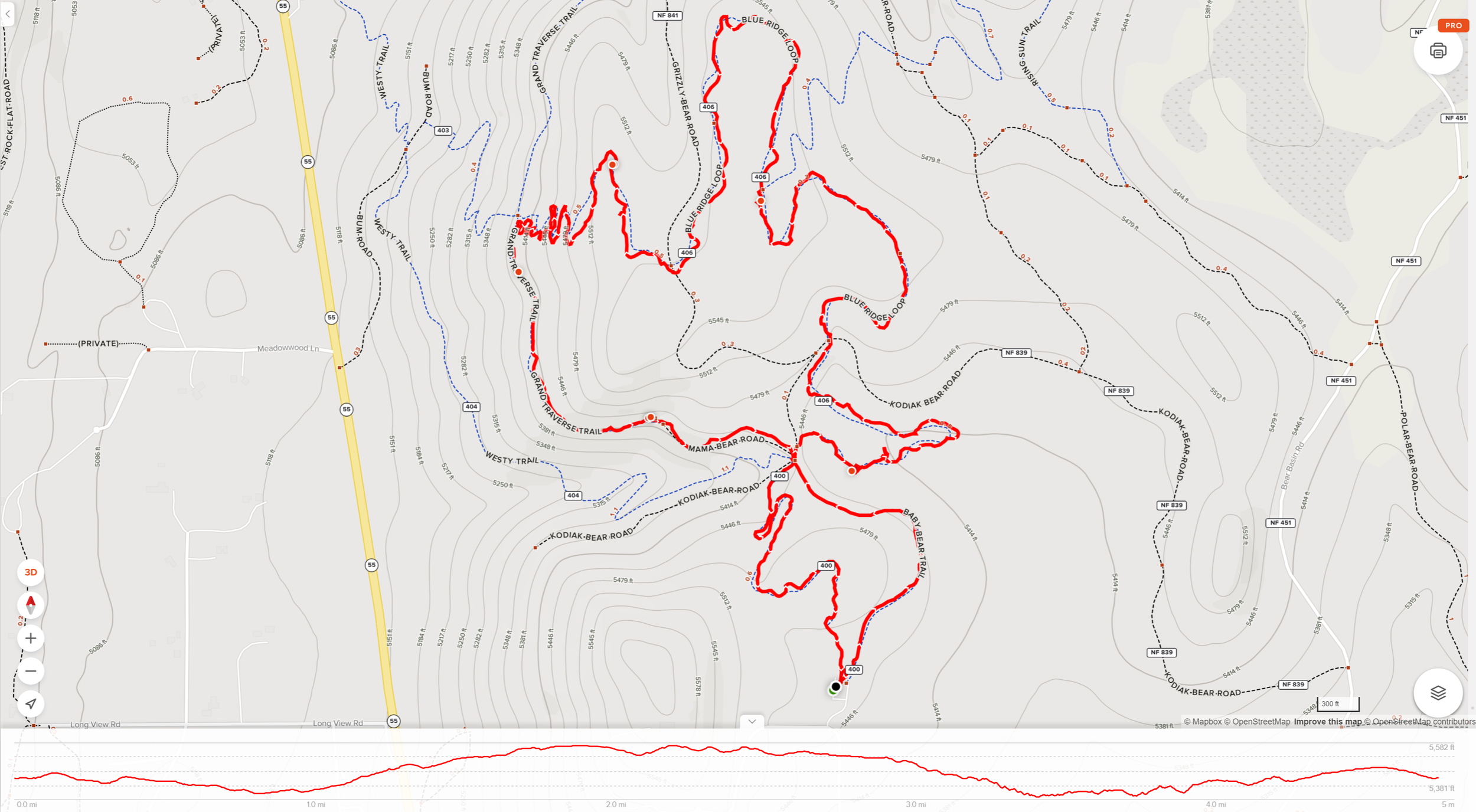
Baby Bear, Sleepy Hollow, Blue Ridge, Upper Drain, and Grand Traverse Trails Loop


As the blog title indicates, this nearly 5-mile loop trail is a combination of several trails. The hike is really incredible as you move through a wooded wetland filled with wildflowers (June) and small bridges, some slight elevations gain up to some terrific views, then through a dirt bike track that is pretty fun on foot as well, with a finish through a less dense wooded area with valley views.
Challenges:
Lots of parking with lots of trail options, so having a navigation tool like AllTrails helps you stay on the right paths.
The first section does have some wetland areas. stay on the paths and bridges and you’ll be fine.
There are some elevation gains during this hike, as well as some pretty steep declines during the mountain bike winding run (top left of above map). This may be limiting for some with mobility issues.
The views often pull your eyes away from the trail, it’s better to just stop and take in the views on this trail. Lots of rocks and roots make their appearance on this trail, so watch your step.
If you go in the summer and during the late morning or afternoon, bring water, sunscreen, and a hat.
Hiker’s Notes:
Trail etiquette dictates that a hiker always makes way for bikes by stepping off the trail so they can pass. This is very important for the mountain bike section. You must keep aware of your surroundings, especially in that section, to avoid getting run over by a bike zooming downhill through banked corners.
Ticks become prevalent in the tall grass after April. Make sure you protect yourself and your dogs if you bring them along.
Equipment:
Water
Snack
Sunscreen (recommended)
Bug Repellent (recommended)
Hat (recommended)
Good, broken in, hiking boots or shoes
Weather-appropriate clothing
The Approach
From downtown McCall, you follow the main road (Highway 55) West, out of town. You’ll follow the road as it bends northwest for about 2.5 miles. At this point be on the lookout for the very sharp right turn off Highway 55 onto N. Club Hill Blvd., and I do mean a very sharp right…you’ll see. Follow this road North for about 0.5 miles. Just as it turns West, you will see the entrance to the parking lot straight ahead of you. (44.934458, -116.153107)
The parking lot is pretty large and any time of day should be fine to arrive, though I imagine it does get really busy in the Summer months on the weekend, like every place in the McCall area.
Grab all your gear and head North to the trailhead. You will notice right away why it is very helpful to have some navigation device to assist. From the trailhead, there are probably a dozen or more branches. Some lead in similar directions and others in very different directions. It is all a bit chaotic looking.
The Trails
There are five trails you will tread on this hike with the first trail reappearing at the end as well. Baby Bear Trail gets you started and is also where you will end. It is a delightful trail that makes a loop all its own if something much shorter is your speed. The trail starts at the trailhead and takes you through a beautiful wooded area with small patches of wetland, cute wood bridges, and lots of wildflowers (June). At times this section seems almost otherworldly, as you traverse from woods to flower-filled meadows. You likely see several varieties of butterflies if you hang out to take in the beauty in this little slice of heaven.
Half a mile in and you will reach a crossroads. Check your map and make sure you take the right trail, although if you make a mistake you’ll generally run into this trail loop again later on. You’re going to now take Sleepy Hollow Trail, which should be the trail to your right. It is actually more of a road, Kodiak Bear Road, for the first 50 yards or so but then the trail breaks off to the right and takes you through some incredible woodland with more meadows, flowers, and butterflies. The end of this trail is where you will start to gain some elevation.
At 1.2 miles you reach the next crossroads where you will just simply cross the road (Kodiak Bear Road), literally. This is where you transition from Sleepy Hollow Trail onto Blue Ridge Loop Trail. This is the longest section of the trail and is where you encounter the most elevation gain. This stretch is a pretty gradual upslope that winds through trees in a pleasant climb. Watch for some of the burned trees in this section, when we walked through several burned trees had mushrooms growing from them, bottom to top. It was an incredible sight as I’d never seen anything like it. (Check out the short video here.)At the top of the climb, you get the payoff of scenic views into the surrounding valley. Let the photo bug in you shine or just pause to breathe deep and enjoy the views, or both.
At 2.6 miles you’ll reach Kodiak Bear Road again and start your descent. Cross straight across the road to Upper Drain Trail on the opposite side. This is where you will need to start paying very close attention to mountain bikes. This section of the trail was made for them and they have the right of way. This is never more evident than when you reach the switchbacks with banked corners. This must be a mountain biking dream ride as they zip down these short stretches with tight banked turns along the way. Just be sure to stay out of their way. If you get a little open window in traffic, have some fun and sprint down a stretch and take the corner as a bike would.
At 3.4 miles you will reach the bottom and merge onto the Grand Traverse Trail. This section has some slight elevation gain, but it is very gradual and minimal. It is a narrow trail along a steep section of the mountain. We saw a lot of yellow flowers, like Arrowleaf Balsamroot and Wild Sunflowers, in this section of the trail. A few clusters of purple Elephant’s Heads, Fireweed, and Lupine make an appearance as well, and with them butterflies, honeybees, and an occasional bumblebee. (Check out the short video here.)
Grand Traverse Trail becomes Mama Bear Road at around the 3.8-mile mark of this trip. Follow this road to the first main intersection you encountered after Baby Bear Loop Trail. There are still some beautiful wildflowers and even some flowering bushes in this section. Take it in as your hike is drawing to a close.
Time for the last stretch of trail as you hike out on the second half of Baby Bear Loop Trail. At about 4.1 miles, this section has a little elevation gain, but it is practically unnoticeable. Take in the wooded area as you make your way back to the main trailhead. Maybe stop and enjoy the youth mountain/dirt bike course before leaving the trail and entering the parking lot.
The Reward
If you have a little extra time and didn’t read the sign board, take a few minutes to learn more about the trails and the area. Finish the hike with a tasty treat back in town, like a milkshake from My Father’s Place or giant scoops of ice cream from Ice Cream Alley. Enjoy your treat as you walk along the Legacy Park walkways and beach. It will make for a day full of memories.