
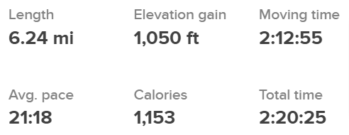
Five Mile Gulch, Watchman, & Three Bears Trails Loop


This loop hike in the Boise Foothills has become a new favorite. It has some great views, diverse landscapes, beautiful wildflowers, a variety of songbirds, and a little challenge to keep it interesting. The trailhead is off Shaw Mountain Rd above Fort Boise (43.630626, -116.106205). Shaw Mountain Rd becomes a somewhat narrow dirt road for about the last 1.5-2 miles before you reach the small parking area. Go slow and watch out for other cars, mountain bikers, joggers, and hikers. Seriously, go slow. This is a popular hiking and mountain biking trailhead, so find a parking spot where you can.
Challenges:
Parking can be difficult depending on when you arrive. The earlier the better.
There are a few stream crossings, but they are easy with stones to step on or bridges in place.
The first 2 miles are mostly a gradual climb. Most of the elevation gain happens here. Take breaks as needed and stay hydrated.
The rest of the trail is pretty level or downhill but be careful, there are lots of roots and rocks that can trip you up. The views often pull your eyes away from the trail, it’s better to just stop and take in the views on this trail.
The last mile is all downhill, but the trail gets pretty sanding so make sure you are wearing good shoes, preferably boots. It is easy to slide and lose your footing.
Hiker’s Notes:
Trail etiquette dictates that a hiker always makes way for bikes by stepping off the trail so they can pass.
Ticks become prevalent in the tall grass after April. Make sure you protect yourself and your dogs if you bring them along.
Equipment:
Water
Snack
Sunscreen (recommended)
Bug Repellent (recommended)
Hat (recommended)
Good, broken in, hiking boots or shoes
Weather-appropriate clothing
I have hiked several of the trails in the foothills, but this was a new one. Previously we tried to keep the length around 4 miles or less. This time we upped the distance and were handsomely rewarded.
The trailhead begins at the small turn-in off the main road where you get to cross the small creek, or you can start to the right of that and avoid the initial creek crossing. From the trailhead, you follow the creek for about 2 miles. This section of the hike has lots of shade in the morning. If there is a breeze, the almost consistent incline will be a little more pleasant. Take time to stop, breathe deep, take in views, listen to the songbirds, and smell the flowers.
During this section, you will come to a fork in the trail, right about the 1.5-mile mark. The trail to the right keeps you on the #2 Five Mile Gulch trail, however, for this loop you want to keep to the left which puts you on Watchman Trail. You’ll find that for every fork on this loop, simply take the left one.
Watchman Trail tends to have a lot more mountain bikes on it. This wasn’t a problem for us at all. We encountered some of the most polite and courteous mountain bikers ever on this trail. They were patient as we stepped to the side if they surprised us coming around a corner on a narrow part of the trail, they always greeted us with friendly salutations, and they would tell us how many there were in their group so we knew when the trail was clear again. It was great. Truly the best example of sharing the trails I have experienced.
Watchman Trail also leaves the wooded canopy of shade behind and for the rest of the hike, you will be in direct sunlight. This is why sunscreen and a hat (wide-brimmed) are recommended. The landscape changes to tall grass and blooming wildflowers. In April and May, the hills are covered with yellow flowers. In June, the yellow flowers die off and give way to a host of other flowers in yellow, purple, and white. The grass in April is just beginning to grow and is a few inches tall, by May it has reached a foot, and by June it is past your knees.
Watchman Trail has another fork at the 2-mile mark. Remember to keep left. This is where you hit pretty level ground, for the most part. Enjoy the scenic skyline as you look out over the Boise Valley at several scenic spots along the trail. At about the 4.3-mile mark, you’ll reach another fork. This is where the bikes tend to diverge from the foot traffic. The bikes either descend or come up from the right trail, while this loop takes you…you guessed it, left.
At this point, you find the landscape shift from steep hillsides to rolling hills. In June, when the grass is above your knees, it is a spectacular reminder of the grassy planes of movies. On a breezy day, you can watch the wind move through the grass causing it to move and sway like waves. It is invigorating.
At the 5.2-mile mark, you reach the final fork in the trail. Keeping left, you will follow the Three Bears Trail back to the dirt road you drove in on. This is the last mile of the hike and takes you closer to a very small creek where a few more trees, and shade, can be found. Enjoy the thick clusters of rose bushes along this stretch of the trail.
Once you reach the road, go left and follow the road about 100 yards, back to your car. If you walk along the right side of the road you get some great views of thick rose bushes lining both sides of the valley along the roadway. Take in the beauty, but be mindful of cars and bikes as you walk along this narrow road.
That is the end of this loop. It was an incredible hike. Certainly my favorite so far of the hikes I have been on in the Boise Foothills.
I hope you enjoy our adventure and get the chance to enjoy this hike yourselves.